THE ANCIENT MERV
To twenty-seven kilometers east of Mary, is
the administrative center of the Mary velayat, the small town of Bairamali, known more for its
health resort.
The town's northern limits come right up to the adobe fortress walls of
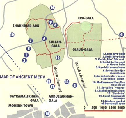
Bairamalikhan-kala, the latest site added to the group ancient settlements which form the State historical and cultural reserve "Ancient Merv".
Its main sites are Sultan-kala (9th-12th centuries), Gyaur-kala (3rd century BC-9th century AD) and Erk-kala (1st millennium ВС) are
7 km away from the modem town. The most ancient excavated site of Merv, Gonur-depe, is
much older than Erk-kala and dates to the middle of the 2nd millennium ВС During that epoch of
the Bronze Age, civilization prospered in the delta of the Murgab river. Some centuries later it
was mentioned in a well-known Bek-histun inscription as the country of Mar-gush. In Avesta
it was called Margav; ancient Greek and Roman geographers called it Margiana and Medieval
Arab and Persian manuscripts described Maru or Merv.
The most ancient monuments of the country of Margush are lost in sand and difficult
to reach. However, archaeologists are excavating intensively there. So, it is better to restrict
sightseeing to those architectural monuments which are concentrated around "The pearl of
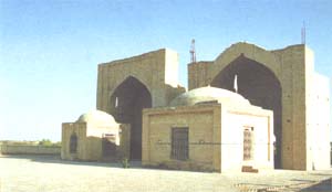
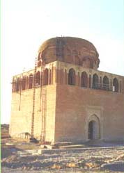
ancient Merv" the Sultan Sandjar Mausoleum, rising high above the center of Sultan-kala.
HISTORY OF MERV
The age of ancient Merv can be determined
approximately only because constant finds and
discoveries convince us that people long before
the foundation of Erk-kala developed the oasis,
approximately 2500 years ago.
It is known that
in the second half of the 4th century ВС, the
Akhemenids captured Margush. In ancient times
the Murgab's delta was a populous oasis and
entered either Baktria or Parthia. In the 4th-3rd
centuries ВС, the son of the founder of the
Selevkid country Antioch built anew the capital
of the region which was given the name of the
Selevkia or Anti-ochia of Margiana (Gyaur-kala
in Merv) and the whole oasis was surrounded by
clay walls 250 km long to shield it from nomads'
raids and desert sand. That wall was 6-7 m wide
and is identified with Gilyakin-Chil-burdj
earthen wall.
Merv's joining the Parthian Empire in the
time of Mitridate II (in the year of 115 ВС
approximately) promoted the town's quick
development as a large craft center and
crossroads of transit trade at the Great Silk Road
between China and Rome. The regular lay-out of
Gyaur-kala remaining from the time of the
Selevkids testifies to the use of Greek urban
development and native traditions: a symmetrical
quadrangle of walls with gates in the center,
where two main roads cross the town. In the
southwestern comer, the Razik canal flowed
through a vaulted tunnel. A thick comer jutting
out for 7 m from the town wall well protected
the water. Besides intensive urban development,
in the Parthian period much work was done to
reconstruct the wall (its width was 10m) and the
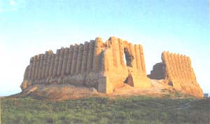
citadel which Erk-kala was transformed into.
The new wall of Gyaur-kala met all the demands
of fortification of that time. More than 100
bastions gave the possibility of flank attack.
Under feudal development, public and
political life in Central Asian towns was
gradually removed out of citadels to developed
new territories protected by fortress walls which
were called shakhristans. In the early feudal
period Gyaur-kala was Merv's shakhristan with an
area of 100 hectares surrounded by walls 30 m
high and 12m wide. At that time it was the largest
city in Middle Asia. Together with suburbs it was
surrounded by the wall (Al-Ray) built in the 3rd
century and fencing a territory 4 km in diameter.
For some time the wall remained under Arabs who
called the shakhristan «Gyaur-kala. « The inner
and outside towns became suburb, irrigated by
four canals, one of which was the Razik. It flowed
to the town through an artificial water supply
filling town reservoirs. The shakhristan consisted
of housing estates, blocks of craftsmen and temple
and palace complexes. In the 6th-7th centuries the
territory of Gyaur-kala was settled only partly and
was not so well developed as during the Parthian
period.
In the second part of the 7th century Southern
Turkmenistan (Northern Khorasan) was invaded
by Arabs who began to introduce a new religion,
Islam. In towns mosques with graceful minarets,
medrassahs, knanakas and other Moslem buildings
began to appear. The first mosques are known
only in written sources. Just after the annexation
of Merv, in the center of Gyaur-kala the
Beni-Makhan mosque was built. It became a
constituent part of the cultural and memorial
complex formed in the 10th-12th centuries. At that
place walls and remnants of a minaret are
archaeologically fixed. When the first mosque
became crowded, another one was built at the
town gate on the Razik canal, and in the middle of
the 8th century the next one was built in the west
on the Madjan canal. By that time Gyaur-kala
almost fell into a state of neglect owing to the
policy of Arabs evicting people from the fortified
shakhristan. So the suburb began to develop, and
the main town life moved there.
In the 9th century, Arab khalifs' power in
agricultural areas of Turkmenistan was replaced
by the power of native feudal dynasties. Since the
year of 821 during 50 years Khorasan was go-
verned by the Takhirid khalifat. They were then
overthrown by the Saffarids who, in their turn, fell
under the Bukhara dynasty of the Samanids. The
latter succeeded in uniting Khorasan, Khoresm
and other regions in the united centralized state
existing during the 10th century. That fairly
prosperous period was marked by excitement of
urban life in the whole region.
In the beginning of the 9th century, being
Khalif al-Mamun's residence and the second
capital of the Arab khalifat, Merv went through a
short but splendid period in its history. No
architectural monument of that time remains, but
it is known that in Gyaur-kala Banu Makhan
mosque was restored. The decay began after al-
Mamun's departure to Baghdad, and the Takhirids
moved the Khorasan rulers' residence to Nishapur.
However, Merv continued to grow to the west
between the Razik and Khurmuzfarra canals.
Perhaps, even at that time, the new part of the
town (Sultan-kala) had an external wall.
The 11th century was marked by the formation
of a powerful Turkmen state led by the Great
Seldjuk dynasty, which made great contributions
to the history of the Middle East. The architectural
peculiarity of the Seldjuk period is the perfection
of brick laying; complicated construction was
done as well as magnificent ornamentation which
was never achieved before.
Merv gained the epithet «Shakjahan» ("soul of
kings") in the 10th century and began to develop
intensively under the Seldjuks. In the period of
Sultan Sanjar, it was the capital of their great country, the largest town in Middle Asia and in the
whole Muslim East (its area together with
suburbs was 1,800 hectares with a population of
150,000 people). Most Central Asian towns had a
population of 2,000-5,000 people; taking that into
consideration, one can imagine the scale of
Seldjuk Merv. It developed from the former
western suburb of Gyaur-kala on the Madjan
canal, where in the middle of the 8th century
Abu-Muslim had moved his residence and a
market, and built a mosque.
In the days of Sultan Melik-Shakh (1072-1092), the clay wall of the suburb, the Central
square part of Sultan-kala was built. At a distance
of 3 m the wall was surrounded by a deep moat
22 m wide and the Razik canal in the east. Along
the perimeter with 20 metro interval there were
about 200 semicircular towers 4 m in diameter
with two-story vaulted rooms for infantrymen.
Walls were 10-12 m high and 6 m wide; inside
there were cells and secret passages.
Under the Seldjuks Merv continued to grow
in the northern and southern directions along the
Madjan canal, dividing the town into two parts. In
the days of Sultan Sandjar, housing and craftsmen's estates, a market and a cemetery appeared
there; they were surrounded by clay defense walls
known as the northern and southern fences.
During that period the life also continued in the
old shakhristan (Gyaur-kala); housing and
craftsmen's estates appeared, and a new mosque
was built in the center instead of the old one.
In 1153 Merv was invaded and cruelly
plundered by Guzzles-nomads. The feudal wars
created anarchy, Khorasan was occupied for some
decades, and all constructive activity ceased.
Only after joining the state of the Khorezmshakhs
could the town partly compensate the damage
caused. In 1221 it was fully destroyed by
Mongols.
After the Mongol invasion Merv was
restored only 200 years later by Shakhrukh, a son
of the great conqueror Emir Timur and the ruler
of an independent state with the capital of Gerat.
In 1418 he ordered to settle Merv. With the
difficulties of water supply the town was moved
to a new place 2 km to the south of Sultan-kala.
Ruins of Timurid Merv are known as Abdul-
lakhan-kala.
In 1454-1457 another Timurid,
Mirza Sanjar, expanded Merv to the adjoining
territory now called Bairama-likhan-kala. Both
sites of the town lie on the same axis, have a
symmetrical plan, are surrounded by fortress
walls with semicircular towers and are encircled
by a moat. The fortress brick gate was like a
developed portal with thick round towers and an
entrance arch. The main town road lay between
them.
During the whole 16th century Merv was
constantly exposed to raids and annexations by
rulers of neighboring countries. In 1510 it entered
the state of the Sefevids and was conquered by
the Sheybanids. Lack of stability led to the
displacement of the ancient West-East trade route
from Merv to Gerat. Only the 17th century passed
fairly quietly for Merv thanks to Khiva's
protection. Total crisis in Middle Asia in the end
of the 17th century and the beginning of the 18th
century, however, generated anarchy again. In
1727 Nadir, the future khan of Iran, evicted all
the people of Merv to Mashad. Ten years later he
himself began to restore the deserted city and the
dam of Sultan-Bend on the Murgab river to
organize an arsenal for a war campaign against
China. After Nadir-shakh's death, strife began
again. The town was being devastated by Afghan
and Bukhara troops. The short government by
Bairamali-khan in 1780's was marked by
widening the Timurid site of the town to the west
where at present there is a market and blocks of
flats in the modem town ofBairamali.
In the end of the 18th century and the
beginning of the 19th century there was an
embittered struggle for Merv unleashed by the
Bukhara emirs. They destroyed the irrigation
system and ravaged the Murgab oasis which
Turkmen tribes such as Salyrs, Saryks and Tekes
began to settle. In 1822 Turkmens drove the
Bukhara emirs out and soon built a fortress far
away from Bairamalikhan-kala on the new banks
of the Murgab, which had changed its bed. So the
present town of Mary was built, unconnected
with the sites of ancient Merv.